
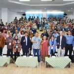
The FMIPA UI Community Engagement Team, led by Dr. Rokhmatuloh, M.Eng. is carrying out community engagement activities in Kelurahan Kalibaru, North Jakarta.
This activity is carried out within 8 months, starting from June and will end in November.
During this period, Rokhmatuloh and the team sought to complete activities with the theme of Utilizing Geographic Information Systems (GIS) & Remote Sensing (PJ) Technology with Participatory Methods for Preparation of Thematic Detailed Maps in Kalibaru Village, Cilincing District, North Jakarta.
The main partner involved in this activity is the dasawisma officer of Kalibaru Village.
“This service program aims to strengthen the function and role of the dasawisma through the spatial presentation of data”. Rokhmat said to the public relations team of FMIPA UI.
According to him, the recapitulation of data collection from dasawisma officers, both manually and application-based, has so far only been presented in the form of tabular statistical data and graphic information.
So that, through this program, Rokhmatuloh and the team trained dasawisma officers to be able to utilize the role of information systems that are oriented towards references on the surface of the earth or spatially, as a basis for decision making for planning and operationalization.
The dasawisma officer is the smallest organ of the Family Welfare Empowerment (PKK) which has a formal duty to collect detailed data on the condition of the community per residential unit.
Rokhmatuloh, who currently serves as Vice Dean of the Faculty of Mathematics and Natural Sciences UI, explained that one dasawisma officer is in charge of ten residential units.
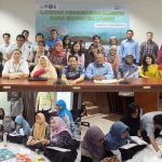
The workshop activities are the beginning of a series of programs. Located in the Kalibaru Kelurahan Hall (10/7), it was attended by representatives of the Dasawisma officers from the Village staff and the PKK management team, the engagement team simulates the use of remote sensing data (photo drones) that can be carried out by the dasawisma officers.
The result was that dasawisma officials were able to map the boundaries of the RT and the distribution of dasawisma in Kalibaru Village.
Monday (5/8) still in the same place, the team held a participatory mapping training to compile detailed thematic maps as a continuation of the workshop activities.
The training involved 50 participants consisting of dasawisma officers, RW representatives, PKK officials, and village staff.
Starting from tabular data that has been collected by dasawisma officers, participants are trained to have skills in the simple spatial data processing.
The output of this stage, partners can obtain information on environmental conditions spatially from maps that have been produced by utilizing Geospatial Information System Technology (GIS).
GIS applications are made using QGis (open source) software that is designed in such a way as to be easily operated by users.
Participants are given one month from the training activity to participative input data on events/conditions in their respective assignments. Furthermore, the results of the update carried out by the participants will be socialized in the second workshop in September.
Also, there are still several other activities that will take place until November, including participatory mapping, participatory data processing, and ending with a seminar on successful activities.
As an effort to maintain the sustainability of the program, since the beginning of the activity, the team has involved the village staff, namely Suyono as Lalib Kalibaru. In this case, Suyono also gave great support by assigning village staff as operators who made updates on the map.
In the future, the community engagement program by FMIPA UI will end by providing optimal, sustainable benefits and increasing environmental insights, for citizens in general, especially for dasawisma officials.