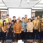


FMIPA UI received an ArcGIS software grant from PT ESRI Indonesia related to geospatial science, as a form of cooperation in supporting national development, through the utilization of all resources in the field of geospatial technology owned by FMIPA UI and ESRI Indonesia.
This was marked by the implementation of the signing of the cooperation agreement by Dr. rer nat. Abdul Haris as the Dean of FMIPA UI and Dr. Achmad Istamar, as the CEO of Esri Indonesia on Wednesday (10/10) in the Floating Room, University of Indonesia, Depok, in a series of G-Days 10th events.
also read: FMIPA UI Holds Geography Days, Dean: Efforts to Grounding Geography to the Community
This collaboration is based on the awareness and desire of the two parties to create harmonious synergy between the Private / Industry and Higher Education institutions in the framework of implementing the Higher Education Tri Dharma Program.
Haris said that this collaboration was more emphasized on aspects of human resource development and community service and conducting scientific research to provide solutions to problems in society.
Dr. Supriatna M.T. The Chair of the Department of Geography FMIPA UI explained that ArcGIS software was very useful for the development of the science of map making in the geospatial field. Not only that, further Supriatna mentioned that this software can be utilized in Urban Management, Regional Planning and Licensing, Disaster Management, Infrastructure Development Planning, and Regional Resources and Potential Management.
The software will also be used free of charge by the UI academic community, students, lecturers, teaching assistants, and researchers in the UI environment in research activities as well as the completion of the final project both thesis, thesis, and dissertation.
To obtain the software license developed by ESRI, continued Supriatna, the UI academic community can apply the Geographic Information System (GIS) Coordinator of the Geography Department of the UI by completing the application form.
Through this collaboration PT ESRI Indonesia also provides facilities for Undergraduate / Masters / Doctoral students for internships within PT ESRI Indonesia’s work environment.
PT ESRI Indonesia will also support maintenance and upgrading of the ArcGIS Platform software by following the existing license period of 2 years, in addition to providing Esri Newsletter, ArcNews and ArcUser bulletin in the form of Hardcopy or Softcopy.
A Brief Definition and Use of ArcGIS
ArcGIS is a software developed by ESRI (Environment Science & Research Institute) which is a compilation of functions from a variety of different GIS software such as desktop, server, and web-based GIS. This software was released by ESRI in 2000.
ESRI (Environmental System Research Institute), based in Redlands, California, is one of the well-established companies in developing software for GIS. Making its debut with ArcInfo 2.0 products in the early 1990s, ESRI continues to improve its products to accommodate various needs in natural resource management and the environment.